Elektronik Su Yönetim Sistemi (ESYS)
ESYS
The Electronic Water Management System is a central management system where various measurement data from different categories are collected, controlled, analyzed, and reported within a single database, combining both mechanical and software components. The formation of this main system occurs after the completion of the software infrastructure.
- Installation of measurement systems in various categories at all desired points for control, reporting, and management of the application area
- Yine uygulama sahasında yapılan ortofoto çalışması ile, ölçüm noktalarının ve parselizasyon bilgilerinin sisteme yüklenmesi.
- The final form is achieved by numerically processing the detailed information of uploaded parcelization and measurement points.

ESYS is an integrated automation system that can be remotely monitored and controlled by authorized regional personnel according to their permissions. It interacts with all proposed measurement stations and control-automation systems (such as canal gate automation) in the region, allowing them to work together as a cohesive and fully operational system.
SYSTEM COMPONENTS
The existing or newly captured up-to-date orthophotos for the area where the system will be installed will be used as the control-command platform for the proposed Elman ESYS SCADA system. The Electronic Control Points (EYN) to be installed in the operating area are as follows:
- Water Level/Flow Measurement Stations
- Regulator/Channel Gate Control Automations
- Hydrant/Agricultural Meter Automation Systems (optional-integrable)
- Underground and Groundwater Measurement Stations (optional-integrable)
- Meteorological Measurement and Observation Stations (optional-integrable)
- Soil and Plant Observation Stations (optional-integrable)
- Drinking Water Observation Stations (optional-integrable)
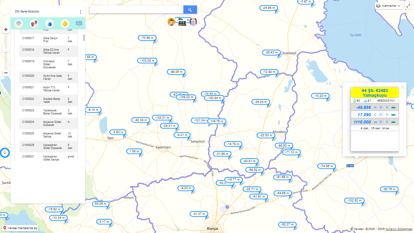
Sistem bir bütün olarak çalıştırılacağı için kapak otomasyonlarının kurulu olduğu kapaklar ilgili gözlem istasyonlarındaki su seviye/debi verisine göre otonom olarak hareket sağlayabileceklerdir.Sisteme girilen tüm katmanlar, sistem kullanımı sırasında istenildiği esneklikte ve kombinasyon ile seçilip, ihtiyaca yönelik olarak yönetim ekranını sadeleştirme yada detaylandırma imkanı sunmaktadır. Böylece kullanıcı o anda sadece ihtiyaç duyduğu bilgilere ulaştığı bir modüler ekrana sahip olmaktadır.Bu sistem aynı zamanda kullanıcının, sistem dahilinde entegre donanımların dahil edildiği mevcut kanal kapak, tarımsal sulama sayacı gibi uzaktan komut ile açma-kapama işlemleri yapabildiği, işleyiş gereği gereken noktalarda komutlarını verebildiği bir kontrol merkezidir.Örneğin, Sulama Birliği sahasında bulunan bir kanal kapağının seviyesini, o an ihtiyacımız olan değere getirebilir ya da kapalı sistem olan bir sulama havzasında kurulu olan uzaktan kontrollü sulama sayaçlarımızdan birini çalıştırabiliriz. Bu sistemin pozitif etkileri sadece kullanım kolaylığı ile sınırlı değildir. Özellikle sulama sahalarında çiftçilerin beyanı ile gerçekte olan sulama sahası farklılıklarının tespiti, ‘’beyan ile gerçekleşen farkı raporu’’ ile çok hızlı bir şekilde yapılarak, kaçak su kullanımı önlenebiliyor. Ya da çiftçilerin sulama sezonu başında beyan ettiği ekin türlerinin sisteme işlenmesi ile sezon başında , su ihtiyacına yönelik en sağlıklı sulama planı rahatlık ile yapılabiliyor. Sistem yöneticisi tarafından o anda hangi tarlanın aktif ve sulanıyor olduğu, planlanan sulamanın % kaçının gerçekleştiği, hangi barajda ne kadar suyun var olduğu ,sulama kanallarındaki su durumunun ne olduğu, bunların hepsi tek bir yönetim ekranından dakika dakika hem tematik hem de sayısal takip edilip raporlanabiliyor. Kısacası sistem, uygulandığı alana ait Yetkili Kullanıcıya sağladığı yönetim ve takip hakimiyeti ile suyun en verimli şekilde ulaşması gereken son noktaya ulaşmasına büyük ölçüde katkı sağlıyor.
BENEFITS AND FEATURES OF THE ELECTRONIC WATER MANAGEMENT SYSTEM
ESYS irrigation planning is developed based on long-term water planning methods and data from various sensors and control points within the operating area, including water level/flow measurement stations, meteorological stations, soil moisture sensors, and crop-specific data.
- DSİ, irrigation unions, and hydroelectric plants will be able to observe or intervene in the system based on their authorities on a common platform.
- The data obtained from water measurement points will change in a thematic live simulation from light to dark according to the flow rate, providing visual control to the user.
- This system does not require any device or location dependency. All authorized users can intervene in the system based on their rights.
- Sistemde yetkili olan her kullanıcı yetkili olduğu bölgede ve oranda Su Gözlem İstasyonlarına, Kapak Kontrol Otomasyonlarına farklı tip ve seviyeler için SET değerleri ve Alarmlar kurabileceklerdir. Bu Alarmlar mobil uygulama ile mekan ve zaman farketmeksizin cihaz yazılımı açık olmasa dahi anında alarm alabilecektir. Bu alarmlar aynı zamanda akıllı saat uygulamalarında da titreşim ve ses ile de ikaz sağlayabilmektedir.
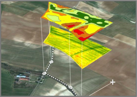
- Technical Data Created by Current Ortho-photo Capture (Irrigation Area, Crop Pattern, etc.)
- Water Demand Declarations Collected at the Beginning of the Irrigation Year
- Crop Pattern to be specified in the request
- Soil type and water permeability (Crop water requirement)
- Real-time meteorological data
- Total water budget
- Real-time and seasonal water budget data of the union
- Long-term water consumption averages (if available 10 years) compared to previous periods
- Water Level/Flow Measurement Stations
- Measurement and Observation Stations of Storage Facilities
- Regulator/Channel Gate Control Automations
- Hydrant/Agricultural Meter Automation Systems
- Underground and Groundwater Measurement Stations
- Meteorological Measurement and Observation Stations
- Soil and Plant Observation Stations
- İçme Suyu Gözlem İstasyonlar
The ESYS system offers different mode options, allowing it to be configured with seasonal modes such as Flood Mode or Summer Water Use Mode, which can be entered into the system. This flexibility enables the system to autonomously or manually manage and track seasonal challenges based on real-time data. In this way, the system can operate as an agricultural irrigation system during the summer and a flood protection and early warning system during the winter.
- ESYS sistemini CBS tabanında çalıştırılmasının başlıca avantajları arasında her parsele(çiftçiye) bir ID(kimlik) numarası atandığı için, her parselin birçok farklı parametre takibi ve yönetimi yapılabilmektedir. Bu parametreler ile her parsel üzerinden;
- Agricultural water demand, usage, tracking, and management are conducted on a parcel/farmer basis.
- Tenant/ownership status (colored on parcel basis) is visible through the system for each parcel/farmer.
- Groundwater level (real-time or weekly/monthly average, colored on parcel basis) is visible for each parcel/farmer.
- Debt and payment status (colored on parcel basis as debtor/non-debtor) for each parcel/farmer is available.
- Real-time irrigation status (colored on parcel basis) for each parcel/farmer is available.
- Crop pattern tracking and analysis (colored on parcel basis) for each parcel/farmer is available.
- Production quantity tracking and analysis (colored on parcel basis) for each parcel/farmer is available.
- Fertilizer and pesticide tracking and analysis (colored on parcel basis) for each parcel/farmer is available.
- Total tracking of water usage and real-time occurrence status in the areas of responsibility of Irrigation Unions/Cooperatives, with tracking and analysis screens available.
IMPORTANCE AND OUTCOMES OF ESYS IRRIGATION MANAGEMENT SYSTEMS
- GIS-based data entry and analysis is performed on the digitized operational map.
- Irrigation planning and control are ensured.
- Improvement of efficiency in water usage.
- Real-time and controlled water level tracking and management.
- Data entry and analysis of crop pattern, fertilizer, pesticides, etc.
- Remote management and level tracking of channel/regulator gate systems (autonomous movement based on water level).
- Active GIS-based map simulated with real-time measurement data allows visual control during every stage of irrigation operations.
- Real-time comparison analysis of irrigation status and total water usage with previous periods and regions.
- Identification of tenant/ownership status of the parcels in the irrigation area on the map.
- Irrigation Planning (Autonomous-Remote Manual)
© Elman - Bu içeriğin tüm hakları Elman’a aittir. İzin alınmadan kullanılması veya paylaşılması yasaktır.